目前常见的激光点云分割算法有基于平面拟合的方法和基于激光点云数据特点的方法两类。具体如下:
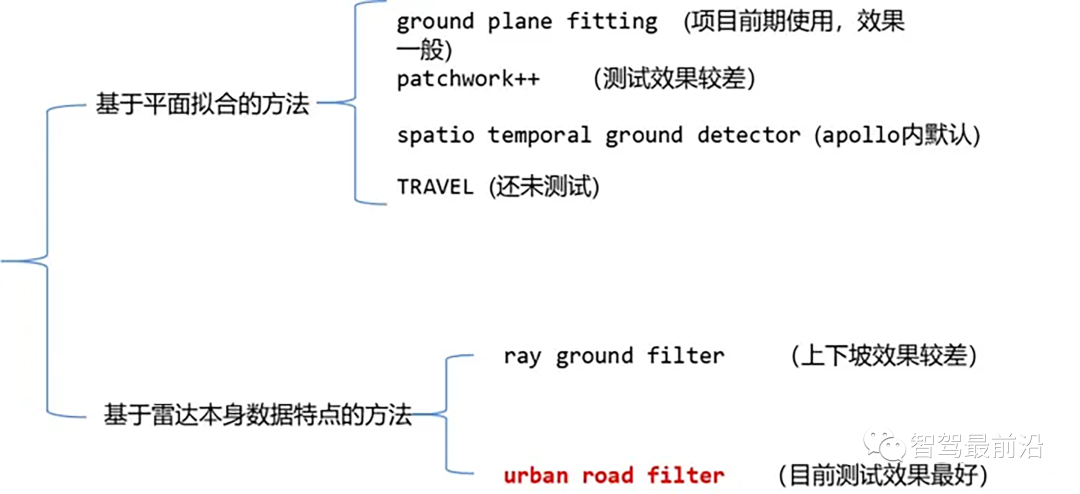
点云地面分割算法
算法思想:一种简单的处理方法就是沿着x方向(车头的方向)将空间分割成若干个子平面,然后对每个子平面使用地面平面拟合算法(GPF)从而得到能够处理陡坡的地面分割方法。该方法是在单帧点云中拟合全局平面,在点云数量较多时效果较好,点云稀疏时极易带来漏检和误检,比如16线激光雷达。
伪代码
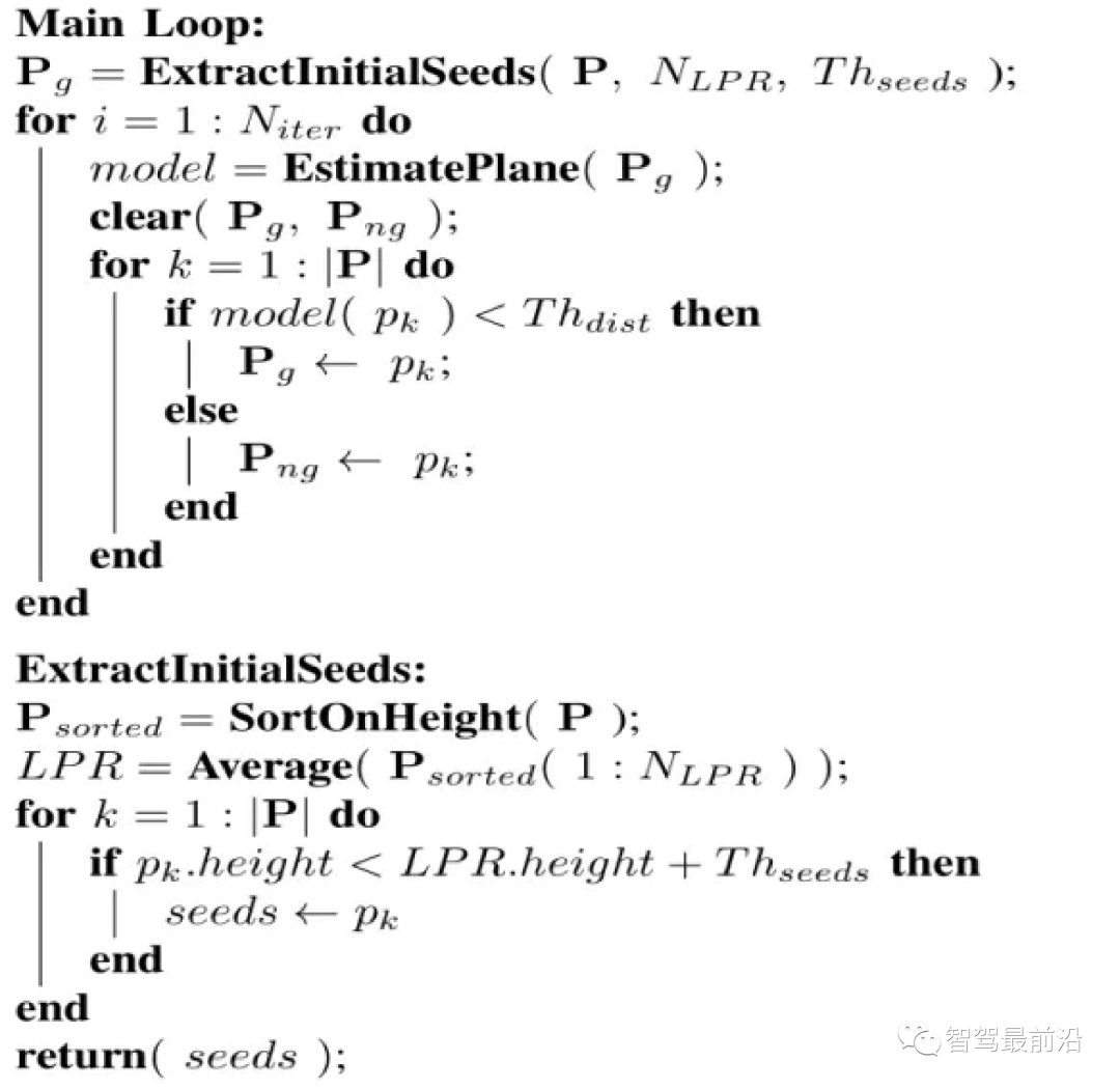
算法流程是对于给定的点云 P ,分割的最终结果为两个点云集合,地面点云 和非地面点云。此算法有四个重要参数,如下:
我们首先选取一个种子点集(seed point set),这些种子点来源于点云中高度(即z值)较小的点,种子点集被用于建立描述地面的初始平面模型,那么如何选取这个种子点集呢?我们引入最低点代表(Lowest Point Representative, LPR)的概念。LPR就是NLPR个最低高度点的平均值,LPR保证了平面拟合阶段不受测量噪声的影响。
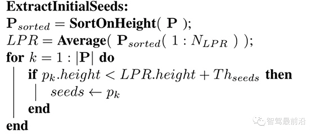
种子点的选择
输入是一帧点云,这个点云内的点已经沿着z方向(即高度)做了排序,取 num_lpr_ 个最小点,求得高度平均值 lpr_height(即LPR),选取高度小于 lpr_height + th_seeds_的点作为种子点。
具体代码实现如下
/*
    @brief Extract initial seeds of the given pointcloud sorted segment.
    This function filter ground seeds points accoring to heigt.
    This function will set the `g_ground_pc` to `g_seed_pc`.
    @param p_sorted: sorted pointcloud

    @param ::num_lpr_: num of LPR points
    @param ::th_seeds_: threshold distance of seeds
    @param ::
*/
void PlaneGroundFilter::extract_initial_seeds_(const pcl::PointCloud<VPoint> &p_sorted)
{
    // LPR is the mean of low point representative
    double sum = 0;
    int cnt = 0;
    // Calculate the mean height value.
    for (int i = 0; i < p_sorted.points.size() && cnt < num_lpr_; i++)
    {
        sum += p_sorted.points[i].z;
        cnt++;
    }
    double lpr_height = cnt != 0 ? sum / cnt : 0; // in case divide by 0
    g_seeds_pc->clear();
    // iterate pointcloud, filter those height is less than lpr.height+th_seeds_
    for (int i = 0; i < p_sorted.points.size(); i++)
    {
        if (p_sorted.points[i].z < lpr_height + th_seeds_)
        {
            g_seeds_pc->points.push_back(p_sorted.points[i]);
        }
    }
    // return seeds points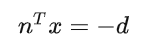
}接下来我们建立一个平面模型,点云中的点到这个平面的正交投影距离小于阈值Thdist,则认为该点属于地面,否则属于非地面。采用一个简单的线性模型用于平面模型估计,如下:
ax+by+cz+d=0
即:
其中
,通过初始点集的协方差矩阵C来求解n,从而确定一个平面,种子点集作为初始点集,其协方差矩阵为
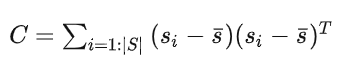
这个协方差矩阵 C 描述了种子点集的散布情况,其三个奇异向量可以通过奇异值分解(SVD)求得,这三个奇异向量描述了点集在三个主要方向的散布情况。由于是平面模型,垂直于平面的法向量 n 表示具有最小方差的方向,可以通过计算具有最小奇异值的奇异向量来求得。
那么在求得了 n 以后, d 可以通过代入种子点集的平均值 ,s(它代表属于地面的点) 直接求得。整个平面模型计算代码如下:
/*
    @brief The function to estimate plane model. The
    model parameter `normal_` and `d_`, and `th_dist_d_`
    is set here.
    The main step is performed SVD(UAV) on covariance matrix.
    Taking the sigular vector in U matrix according to the smallest
    sigular value in A, as the `normal_`. `d_` is then calculated
    according to mean ground points.


    @param g_ground_pc:global ground pointcloud ptr.

*/
void PlaneGroundFilter::estimate_plane_(void)
{
    // Create covarian matrix in single pass.
    // TODO: compare the efficiency.
    Eigen::Matrix3f cov;
    Eigen::Vector4f pc_mean;
    pcl::computeMeanAndCovarianceMatrix(*g_ground_pc, cov, pc_mean);
    // Singular Value Decomposition: SVD
    JacobiSVD<MatrixXf> svd(cov, Eigen::DecompositionOptions::ComputeFullU);
    // use the least singular vector as normal
    normal_ = (svd.matrixU().col(2));
    // mean ground seeds value
    Eigen::Vector3f seeds_mean = pc_mean.head<3>();


    // according to normal.T*[x,y,z] = -d
    d_ = -(normal_.transpose() * seeds_mean)(0, 0);
    // set distance threhold to `th_dist - d`
    th_dist_d_ = th_dist_ - d_;


    // return the equation parameters
}extract_initial_seeds_(laserCloudIn);
g_ground_pc = g_seeds_pc;
// Ground plane fitter mainloop
for (int i = 0; i < num_iter_; i++)
{
estimate_plane_();
g_ground_pc->clear();
g_not_ground_pc->clear();
//pointcloud to matrix
MatrixXf points(laserCloudIn_org.points.size(), 3);
int j = 0;
for (auto p : laserCloudIn_org.points)
{
points.row(j++) << p.x, p.y, p.z;
}
// ground plane model
VectorXf result = points * normal_;
// threshold filter
for (int r = 0; r < result.rows(); r++)
{
if (result[r] < th_dist_d_)
{
g_all_pc->points[r].label = 1u; // means ground
g_ground_pc->points.push_back(laserCloudIn_org[r]);
}
else
{
g_all_pc->points[r].label = 0u; // means not ground and non clusterred
g_not_ground_pc->points.push_back(laserCloudIn_org[r]);
}
}
}得到这个初始的平面模型以后,我们会计算点云中每一个点到该平面的正交投影的距离,即 points * normal_,并且将这个距离与设定的阈值(即th_dist_d_) 比较,当高度差小于此阈值,我们认为该点属于地面,当高度差大于此阈值,则为非地面点。经过分类以后的所有地面点被当作下一次迭代的种子点集,迭代优化。
https://github.com/suyunzzz/ray_filter_ground
Ray Ground Filter算法的核心是以射线(Ray)的形式来组织点云。将点云的 (x, y, z)三维空间降到(x,y)平面来看,计算每一个点到车辆x正方向的平面夹角 θ, 对360度进行微分,分成若干等份,每一份的角度为0.2度。
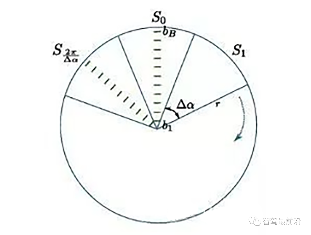
激光线束等间隔划分示意图(通常以激光雷达角度分辨率划分)
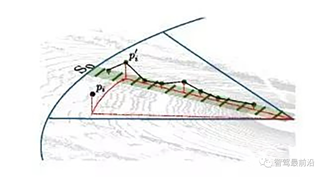
同一角度范围内激光线束在水平面的投影以及在Z轴方向的高度折线示意图
为了方便对同一角度的线束进行处理,要将原来直角坐标系的点云转换成柱坐标描述的点云数据结构。对同一夹角的线束上的点按照半径的大小进行排序,通过前后两点的坡度是否大于我们事先设定的坡度阈值,从而判断点是否为地面点。
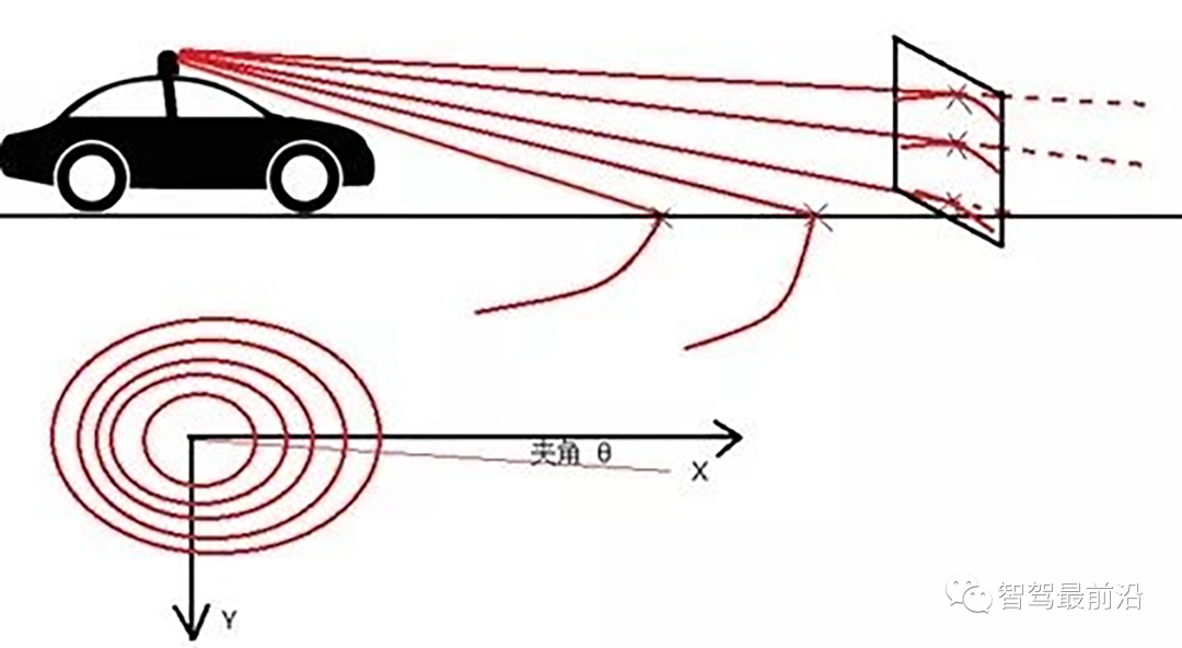
线激光线束纵截面与俯视示意图(n=4)
通过如下公式转换成柱坐标的形式:
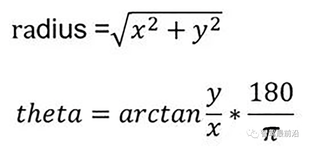
转换成柱坐标的公式
radius表示点到lidar的水平距离(半径),theta是点相对于车头正方向(即x方向)的夹角。对点云进行水平角度微分之后,可得到1800条射线,将这些射线中的点按照距离的远近进行排序。通过两个坡度阈值以及当前点的半径求得高度阈值,通过判断当前点的高度(即点的z值)是否在地面加减高度阈值范围内来判断当前点是为地面。
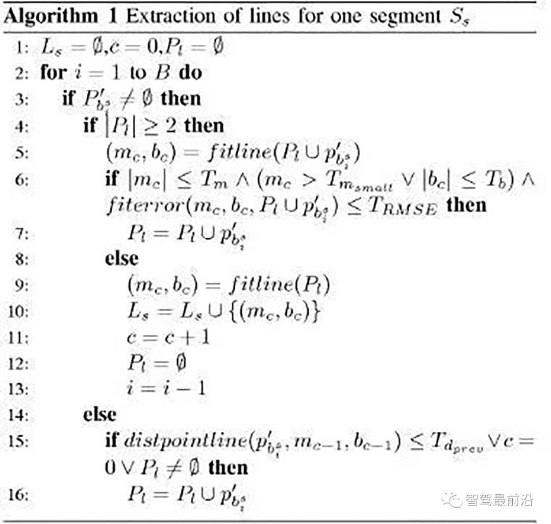
伪代码
遍历1800条射线,对于每一条射线进行如下操作:
1.计算当前点和上一个点的水平距离pointdistance
2.根据local_max_slope_和pointdistance计算当前的坡度差阈值height_threshold
3.根据general_max_slope_和当前点的水平距离计算整个地面的高度差阈值general_height_threshold
4.若当前点的z坐标小于前一个点的z坐标加height_threshold并大于前一个点的z坐标减去height_threshold:
5.若当前点z坐标小于雷达安装高度减去general_height_threshold并且大于相加,认为是地面点
6.否则:是非地面点。
7.若pointdistance满足阈值并且前点的z坐标小于雷达安装高度减去height_threshold并大于雷达安装高度加上height_threshold,认为是地面点。
/*!
 *
 * @param[in] in_cloud Input Point Cloud to be organized in radial segments
 * @param[out] out_organized_points Custom Point Cloud filled with XYZRTZColor data
 * @param[out] out_radial_divided_indices Indices of the points in the original cloud for each radial segment
 * @param[out] out_radial_ordered_clouds Vector of Points Clouds, each element will contain the points ordered
 */
void PclTestCore::XYZI_to_RTZColor(const pcl::PointCloud<pcl::PointXYZI>::Ptr in_cloud,
                                   PointCloudXYZIRTColor &out_organized_points,
                                   std::vector<pcl::PointIndices> &out_radial_divided_indices,
                                   std::vector<PointCloudXYZIRTColor> &out_radial_ordered_clouds)
{
    out_organized_points.resize(in_cloud->points.size());
    out_radial_divided_indices.clear();
    out_radial_divided_indices.resize(radial_dividers_num_);
    out_radial_ordered_clouds.resize(radial_dividers_num_);

    for (size_t i = 0; i < in_cloud->points.size(); i++)
    {
        PointXYZIRTColor new_point;
//计算radius和theta
//方便转到柱坐标下。
        auto radius = (float)sqrt(
            in_cloud->points[i].x * in_cloud->points[i].x + in_cloud->points[i].y * in_cloud->points[i].y);
        auto theta = (float)atan2(in_cloud->points[i].y, in_cloud->points[i].x) * 180 / M_PI;
        if (theta < 0)
        {
            theta += 360;
        }
        //角度的微分
        auto radial_div = (size_t)floor(theta / RADIAL_DIVIDER_ANGLE);
        //半径的微分
        auto concentric_div = (size_t)floor(fabs(radius / concentric_divider_distance_));

        new_point.point = in_cloud->points[i];
        new_point.radius = radius;
        new_point.theta = theta;
        new_point.radial_div = radial_div;
        new_point.concentric_div = concentric_div;
        new_point.original_index = i;

        out_organized_points[i] = new_point;

        //radial divisions更加角度的微分组织射线
        out_radial_divided_indices[radial_div].indices.push_back(i);

        out_radial_ordered_clouds[radial_div].push_back(new_point);

    } //end for

    //将同一根射线上的点按照半径(距离)排序
#pragma omp for
    for (size_t i = 0; i < radial_dividers_num_; i++)
    {
        std::sort(out_radial_ordered_clouds[i].begin(), out_radial_ordered_clouds[i].end(),
                  [](const PointXYZIRTColor &a, const PointXYZIRTColor &b) { return a.radius < b.radius; });
    }
}

/*!
 * Classifies Points in the PointCoud as Ground and Not Ground
 * @param in_radial_ordered_clouds Vector of an Ordered PointsCloud ordered by radial distance from the origin
 * @param out_ground_indices Returns the indices of the points classified as ground in the original PointCloud
 * @param out_no_ground_indices Returns the indices of the points classified as not ground in the original PointCloud
 */
void PclTestCore::classify_pc(std::vector<PointCloudXYZIRTColor> &in_radial_ordered_clouds,
                              pcl::PointIndices &out_ground_indices,
                              pcl::PointIndices &out_no_ground_indices)
{
    out_ground_indices.indices.clear();
    out_no_ground_indices.indices.clear();
#pragma omp for
    for (size_t i = 0; i < in_radial_ordered_clouds.size(); i++) //sweep through each radial division 遍历每一根射线
    {
        float prev_radius = 0.f;
        float prev_height = -SENSOR_HEIGHT;
        bool prev_ground = false;
        bool current_ground = false;
        for (size_t j = 0; j < in_radial_ordered_clouds[i].size(); j++) //loop through each point in the radial div
        {
            float points_distance = in_radial_ordered_clouds[i][j].radius - prev_radius;//计算当前点和上一个点的水平距离pointdistance
            float height_threshold = tan(DEG2RAD(local_max_slope_)) * points_distance;//根据local_max_slope_和pointdistance计算当前的坡度差阈值height_threshold
            float current_height = in_radial_ordered_clouds[i][j].point.z;
            float general_height_threshold = tan(DEG2RAD(general_max_slope_)) * in_radial_ordered_clouds[i][j].radius;//根据general_max_slope_和当前点的水平距离计算整个地面的高度差阈值general_height_threshold

            //for points which are very close causing the height threshold to be tiny, set a minimum value
            if (points_distance > concentric_divider_distance_ && height_threshold < min_height_threshold_)
            {
                height_threshold = min_height_threshold_;
            }

            //check current point height against the LOCAL threshold (previous point)
            if (current_height <= (prev_height + height_threshold) && current_height >= (prev_height - height_threshold))
            {
                //Check again using general geometry (radius from origin) if previous points wasn't ground
                if (!prev_ground)
                {
                    if (current_height <= (-SENSOR_HEIGHT + general_height_threshold) && current_height >= (-SENSOR_HEIGHT - general_height_threshold))
                    {
                        current_ground = true;
                    }
                    else
                    {
                        current_ground = false;
                    }
                }
                else
                {
                    current_ground = true;
                }
            }
            else
            {
                //check if previous point is too far from previous one, if so classify again
                if (points_distance > reclass_distance_threshold_ &&
                    (current_height <= (-SENSOR_HEIGHT + height_threshold) && current_height >= (-SENSOR_HEIGHT - height_threshold)))
                {
                    current_ground = true;
                }
                else
                {
                    current_ground = false;
                }
            }

            if (current_ground)
            {
                out_ground_indices.indices.push_back(in_radial_ordered_clouds[i][j].original_index);
                prev_ground = true;
            }
            else
            {
                out_no_ground_indices.indices.push_back(in_radial_ordered_clouds[i][j].original_index);
                prev_ground = false;
            }

            prev_radius = in_radial_ordered_clouds[i][j].radius;
            prev_height = in_radial_ordered_clouds[i][j].point.z;
        }
    }
}Real-Time LIDAR-Based Urban Road and Sidewalk Detection for Autonomous Vehicles
https://github.com/jkk-research/urban_road_filter
z_zero_method
首先将数据组织成[channels][thetas]
对于每一条线,对角度进行排序
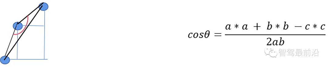
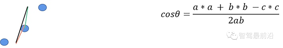
如果余弦角度满足阈值且max1减去p.z满足阈值或max2减去p.z满足阈值且max2-max1满足阈值,认为此点为障碍物,否则就认为是地面点。
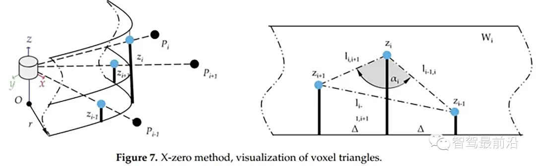
X-zero和Z-zero方法可以找到避开测量的X和Z分量的人行道,X-zero和Z-zero方法都考虑了体素的通道数,因此激光雷达必须与路面平面不平行,这是上述两种算法以及整个城市道路滤波方法的已知局限性。X-zero方法去除了X方向的值,使用柱坐标代替。
x_zero_method
首先将数据组织成[channels][thetas]
对于每一条线,对角度进行排序
如果余弦角度满足阈值且p1.z-p.z满足阈值或p1.z-p2.z满足阈值且p.z-p2.z满足阈值,认为此点为障碍物
该方法将点云划分为矩形段,这些形状的组合像一颗星;这就是名字的来源,从每个路段提取可能的人行道起点,其中创建的算法对基于Z坐标的高度变化不敏感,这意味着在实践中,即使当激光雷达相对于路面平面倾斜时,该算法也会表现良好,在柱坐标系中处理点云。
具体实现:
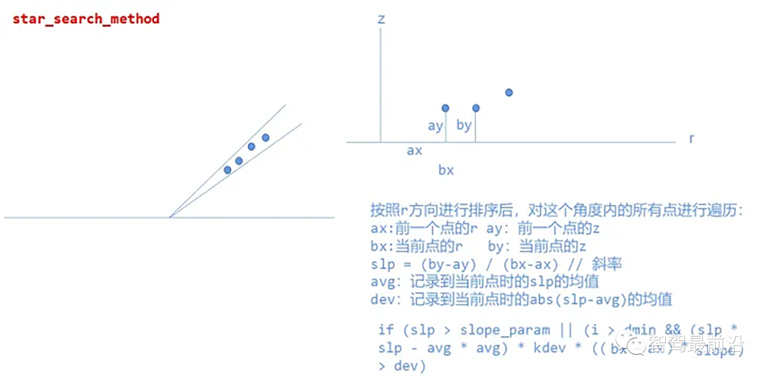
star_search_method
总的来说,我对ruby还比较陌生,我正在为我正在创建的对象编写一些rspec测试用例。许多测试用例都非常基础,我只是想确保正确填充和返回值。我想知道是否有办法使用循环结构来执行此操作。不必为我要测试的每个方法都设置一个assertEquals。例如:describeitem,"TestingtheItem"doit"willhaveanullvaluetostart"doitem=Item.new#HereIcoulddotheitem.name.shouldbe_nil#thenIcoulddoitem.category.shouldbe_nilendend但我想要一些方法来使用
很好奇,就使用rubyonrails自动化单元测试而言,你们正在做什么?您是否创建了一个脚本来在cron中运行rake作业并将结果邮寄给您?git中的预提交Hook?只是手动调用?我完全理解测试,但想知道在错误发生之前捕获错误的最佳实践是什么。让我们理所当然地认为测试本身是完美无缺的,并且可以正常工作。下一步是什么以确保他们在正确的时间将可能有害的结果传达给您? 最佳答案 不确定您到底想听什么,但是有几个级别的自动代码库控制:在处理某项功能时,您可以使用类似autotest的内容获得关于哪些有效,哪些无效的即时反馈。要确保您的提
我试图在一个项目中使用rake,如果我把所有东西都放到Rakefile中,它会很大并且很难读取/找到东西,所以我试着将每个命名空间放在lib/rake中它自己的文件中,我添加了这个到我的rake文件的顶部:Dir['#{File.dirname(__FILE__)}/lib/rake/*.rake'].map{|f|requiref}它加载文件没问题,但没有任务。我现在只有一个.rake文件作为测试,名为“servers.rake”,它看起来像这样:namespace:serverdotask:testdoputs"test"endend所以当我运行rakeserver:testid时
作为我的Rails应用程序的一部分,我编写了一个小导入程序,它从我们的LDAP系统中吸取数据并将其塞入一个用户表中。不幸的是,与LDAP相关的代码在遍历我们的32K用户时泄漏了大量内存,我一直无法弄清楚如何解决这个问题。这个问题似乎在某种程度上与LDAP库有关,因为当我删除对LDAP内容的调用时,内存使用情况会很好地稳定下来。此外,不断增加的对象是Net::BER::BerIdentifiedString和Net::BER::BerIdentifiedArray,它们都是LDAP库的一部分。当我运行导入时,内存使用量最终达到超过1GB的峰值。如果问题存在,我需要找到一些方法来更正我的代
Rails2.3可以选择随时使用RouteSet#add_configuration_file添加更多路由。是否可以在Rails3项目中做同样的事情? 最佳答案 在config/application.rb中:config.paths.config.routes在Rails3.2(也可能是Rails3.1)中,使用:config.paths["config/routes"] 关于ruby-on-rails-Rails3中的多个路由文件,我们在StackOverflow上找到一个类似的问题
我需要从一个View访问多个模型。以前,我的links_controller仅用于提供以不同方式排序的链接资源。现在我想包括一个部分(我假设)显示按分数排序的顶级用户(@users=User.all.sort_by(&:score))我知道我可以将此代码插入每个链接操作并从View访问它,但这似乎不是“ruby方式”,我将需要在不久的将来访问更多模型。这可能会变得很脏,是否有针对这种情况的任何技术?注意事项:我认为我的应用程序正朝着单一格式和动态页面内容的方向发展,本质上是一个典型的网络应用程序。我知道before_filter但考虑到我希望应用程序进入的方向,这似乎很麻烦。最终从任何
我在我的项目中添加了一个系统来重置用户密码并通过电子邮件将密码发送给他,以防他忘记密码。昨天它运行良好(当我实现它时)。当我今天尝试启动服务器时,出现以下错误。=>BootingWEBrick=>Rails3.2.1applicationstartingindevelopmentonhttp://0.0.0.0:3000=>Callwith-dtodetach=>Ctrl-CtoshutdownserverExiting/Users/vinayshenoy/.rvm/gems/ruby-1.9.3-p0/gems/actionmailer-3.2.1/lib/action_mailer
刚入门rails,开始慢慢理解。有人可以解释或给我一些关于在application_controller中编码的好处或时间和原因的想法吗?有哪些用例。您如何为Rails应用程序使用应用程序Controller?我不想在那里放太多代码,因为据我了解,每个请求都会调用此Controller。这是真的? 最佳答案 ApplicationController实际上是您应用程序中的每个其他Controller都将从中继承的类(尽管这不是强制性的)。我同意不要用太多代码弄乱它并保持干净整洁的态度,尽管在某些情况下ApplicationContr
我想向我的Controller传递一个参数,它是一个简单的复选框,但我不知道如何在模型的form_for中引入它,这是我的观点:{:id=>'go_finance'}do|f|%>Transferirde:para:Entrada:"input",:placeholder=>"Quantofoiganho?"%>Saída:"output",:placeholder=>"Quantofoigasto?"%>Nota:我想做一个额外的复选框,但我该怎么做,模型中没有一个对象,而是一个要检查的对象,以便在Controller中创建一个ifelse,如果没有检查,请帮助我,非常感谢,谢谢
我注意到像bundler这样的项目在每个specfile中执行requirespec_helper我还注意到rspec使用选项--require,它允许您在引导rspec时要求一个文件。您还可以将其添加到.rspec文件中,因此只要您运行不带参数的rspec就会添加它。使用上述方法有什么缺点可以解释为什么像bundler这样的项目选择在每个规范文件中都需要spec_helper吗? 最佳答案 我不在Bundler上工作,所以我不能直接谈论他们的做法。并非所有项目都checkin.rspec文件。原因是这个文件,通常按照当前的惯例,只